Where Are We?: A Look at Global Positioning Systems on the Market Today
The global positioning system (GPS) was developed by the U.S. Department of Defense to provide information about location, such as the coordinates of a military target. It is now available for public use and has been incorporated into many products, including boats, cars, planes, laptop computers, and even telephones. GPS technology is especially useful for anyone who travels a lot and knows the feeling of getting lost.
How Does It Work?
The Department of Defense launched 24 satellites into orbit, and using signals from these satellites, a GPS receiver can calculate such information as altitude, longitude, and latitude. A GPS receiver needs to be in the view of at least three of these satellites to provide accurate data. Depending on the location of the GPS receiver, precision can be down to a few feet. The ideal conditions for GPS are a large open space with a direct view of the sky. Unfortunately, the signal is less than optimal in a city with tall skyscrapers that obstruct the view of the GPS receiver. For a more in-depth explanation of GPS, visit <www.trimble.com/gps/>.
GPS has obvious potential for blind and visually impaired people who think that the orientation in orientation and mobility is the hard part. If you have ever sought directions from well-meaning pedestrians, you know that the information is often not reliable. GPS technology strives to be the "ideal pedestrian," providing precise information in a coherent way without the extra baggage of quirky human interaction. Ever wonder if your taxi driver was "taking you for a ride"? GPS has the potential to provide you as a passenger with information about where you are and where you are heading.
We start off by looking at three laptop-based GPS systems that range in price from $150 to $400. We chose laptop-based systems because they can be used with screen readers and screen magnifiers. A laptop-based system includes a GPS receiver, which is a piece of hardware that connects to a laptop, and mapping software that uses the GPS receiver to tell you where you are and where you need to go. The limitation of laptop-based GPS systems is that they are not convenient to use as you travel–because of the weight of most laptops. We then take a look at two cell phone-based GPS systems that range in price from $200 to $500. These devices not only give you your precise location but can aid in an emergency as well.
Products by Sendero Group also need to be mentioned because the company specializes in GPS technology for use by blind and visually impaired persons. Atlas is mapping software with built-in speech output that can plan a route before you leave on a trip. It provides information on street names and directions, as well as on any points of interest, such as restaurants.
Sendero Group recently teamed up with HumanWare to develop a GPS product that works on HumanWare's electronic note takers—VoiceNote or BrailleNote. Rather than provide a full map database, it will provide direction of travel, distance to destination, distance to a turn, and speed of travel. AccessWorld will review GPS-Talk in a future issue.
Locating the Best GPS System
We were looking for the following attributes in a GPS system:
- The interface should be intuitive and the product easy to figure out.
- Computer-based systems need to be accessible by both screen magnifiers and screen readers. If a product has its own speech output, it needs to be able to read all the controls as well as give directions.
- Map information, such as the direction of travel or an upcoming street, must be presented in a manner that is accessible to a user who is blind.
Questions to Ask Before You Buy
The number one question to ask yourself is, "Does this GPS system give me the information I need in the way I want it?" A GPS system would no doubt work well when you sort of know how to get somewhere but would like information to confirm where you think you are in relation to where you should be. It certainly can provide useful information to the independent traveler who wants to be even more of an independent traveler and with less effort. Beyond the type of informational help it will provide, there are also questions you need to ask about how the GPS system is carried around and how it communicates with you and you with it.
Does the GPS system provide enough information to be helpful but not too much to be distracting? If it uses speech output, can you hear it, and if it uses speech recognition, can it hear you? Is it convenient to carry and use? You don't want to be burdened with a lot of bulky gear. And you don't want to be forced to stop and fiddle with the gear every time you need to get information on your location. Where are you intending to use the GPS system? Don't forget that any GPS system needs a view of the sky to work, so it won't work indoors and has problems when you are near tall buildings that obstruct its view of the sky. Also, the information you get is only as good as the map database that comes with the GPS system. Is your neighborhood undergoing extensive street changes? If so, don't expect to see those changes reflected in your GPS system until the map database is updated. Finally, when researching GPS systems, always remember to ask yourself, "Is this product going to give me the information I need in the way I want it?"
Laptop-Based Systems
CoPilot 2002
TravRoute's CoPilot will dynamically generate directions as you move. When started, CoPilot displays edit boxes to enter in a destination by street address. It automatically pinpoints your current location, which is the starting location. It then announces the direction in which to start walking or driving. As you approach an intersection, it announces that a turn is coming up. If a turn is missed, it recalculates the route. CoPilot is effective in that once you set it up, no keys need to be pressed. It automatically speaks and displays information when necessary.
For a user with low vision, CoPilot's interface is quite accessible (see Figure 1). The contrast is high (white text on a black background), and the font size is large. The screen is not cluttered, and the map is simple. Overall, CoPilot is easy to view. It uses both speech output and speech recognition to communicate with the user. It reads out controls, but it does not work as well as it should. Many times it is delayed or misses controls altogether. Arrow keys are used to move the focus to the next control in the direction of the arrow you push. Sight is required to know which direction the next control is in.

Caption: Figure 1. CoPilot interface.
Street Atlas U.S.A. Deluxe
Delorme's Street Atlas U.S.A. Deluxe is the GPS software, and Earthmate is the receiver, which can be purchased separately or as a package with the software. For the most part, Street Atlas offers the same features as CoPilot, but its interface is much more complicated (see Figure 2). Actually, Street Atlas has more features, but none of the extras offered, such as a tool to draw in your own secondary roads as any new streets develop in a community, is particularly valuable.
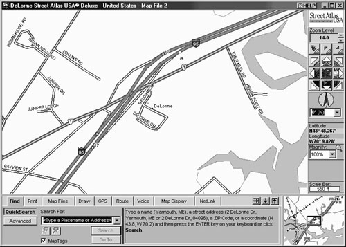
Caption: Figure 2. Street Atlas interface.
For the visually impaired user, the interface is not well designed. There is too much clutter on the screen, and the text lacks contrast and size. The maps have more detail than needed, making them harder to interpret.
Street Atlas uses both speech output and speech recognition to communicate with the user. Unfortunately, the built-in speech output does not read controls, so it is of no use to a blind user. A blind person using a screen reader could use Street Atlas, but it would take patience. The controls are ordered in a way that forces a keyboard user to cycle through many more controls than normally would be necessary. On the positive side, all Street Atlas's controls have tool tips, which are a definite plus. A tool tip is a small window with text that is displayed and read by screen readers as a control comes into focus. The text gives a description of what the control does.
MapSource MetroGuide U.S.A
MetroGuide, by Garmin, uses any of a number of Garmin receivers, all of which can work as stand-alones or be connected to a laptop. We chose the eMap receiver, since it has the largest display (2x2.5 inches). We tested it as both a stand-alone and with a laptop.
The Garmin eMap receiver has eight buttons and a direction pad similar to a miniversion of the arrows on a keyboard (see Figure 3). The display on the receiver shows a map of your current surroundings, as well as a small triangle showing your current location. As you move, the triangle moves, and the map adjusts itself accordingly. The features and functions on the eMap includes zooming in and out; an illuminated backlit display; and the ability to retrieve information, such as current speed, altitude, and direction. But don't get your hopes up.

Caption: Figure 3. eMap receiver.
The eMap's display has four gray-shade colors, so it doesn't have good contrast. In addition, everything is drawn extremely small to fit on this screen. There is no speech output or input. The buttons are small, leaving the text on the buttons small as well.
MetroGuide is the software that can be used along with the eMap on a laptop (see Figure 4). It has functions similar to both CoPilot and Street, but it has no speech input or output. Someone with low vision can use MetroGuide, but a blind person cannot because the information that is given by the graphical map is not given in any other forms, such as text or speech output.

Caption: Figure 4. MetroGuide interface.
Cell Phones and GPS
We tested two different cell phones: MobilePal+GPS, made by RemoteMDx, and Navtalk, made by Garmin.
MobilePal+GPS
The MobilePal is a personal assistance device that provides a one-touch connection with a personal assistance operator who is available 24 hours a day, 7 days a week. In an emergency, the personal assistance operator can perform tasks like dispatching police, fire, ambulance, or roadside assistance anywhere in the United States. The personal assistance operator can also connect you to any phone number. The feature that separates the MobilePal from other communication devices is its use of GPS to inform your personal assistance operator automatically of your location when called.
The MobilePal only has two buttons on it (see Figure 5). The first button, which is large and red, is located where the numbers normally would be. It is used to contact a personal assistant operator. The second button, located on the side of the phone, activates a piercing siren to get attention quickly.

Caption: Figure 5. MobilePal.
Performance does not match accessibility. While trying out MobilePal, we found it to be highly unreliable. There was a lot of static on the line, and many times we could not get through to an operator at all. At other times, we had to wait up to five minutes to get connected.
Navtalk
Navtalk is much more complex than MobilePal. It works like a normal cell phone in that it has a full keypad, built-in address book, and message center to retrieve missed calls. Navtalk also offers emergency/roadside assistance for an extra price that automatically sends your location to the operator if called. Its built-in display, similar to the eMap's, shows your current location and the surrounding area map (see Figure 6).

Caption: Figure 6. Navtalk.
As for ease of use and accessibility, Navtalk has over 20 buttons on the front of it, all of which are tiny. Good luck in an emergency when you need to hit the right buttons and quickly! In addition, the screen is small and has low contrast.
The End of the Road
A visually impaired person can use all three laptop-based systems. A high-contrast display, large font, and uncomplicated maps make CoPilot the most accessible by far. The eMap is noteworthy, since it is the only stand-alone system, but accessibility is poor. A blind person can use Street Atlas, but it is cumbersome. CoPilot and MetroGuide are not accessible to blind users. As far as cell phones go, MobilePal is accessible to blind and visually impaired users, but Navtalk is not. But MobilePal needs to work out some operational bugs to make it worth considering.
The off-the-shelf GPS systems we tried have great potential, but they are not yet user friendly. If you need to be the first on your block to have one, be sure to try various systems before you buy.
Product Information
CoPilot 2002 (Windows 95, 98, ME, NT, 2000)
Manufacturer: TravRoute, 1000 Herrontown Road, Princeton, NJ 08540; phone: 609-252-8197; e-mail: <salesinfo@traveroute.com>; web site: <www.travroute.com>. Price: $399.
Earthmate GPS Receiver with Street Atlas U.S.A. (Windows 95, 98, ME, NT, 2000)
Manufacturer: DeLorme, 2 DeLorme Drive, P.O. Box 298, Yarmouth, ME 04096; phone: 207-846-7000; e-mail: <sales@delorme.com>; web site: <www.delorme.com>. Price: $179.95.
MapSource MetroGuide U.S.A (Windows 95, 98, ME, NT, 2000)
Manufacturer: Garmin, 1200 East 151 Street, Olathe, KS 66062; phone: 913-397-8200; e-mail: <sales@garmin.com>; web site: <www.garmin.com>. Price: $174.98.
Atlas (Windows 3.1, 95, 98, ME)
Manufacturer: Sendero Group, 175 Mason Circle, Concord, CA 94520; phone: 530-757- 6800; e-mail: <info@senderogroup.com>; web site: <www.senderogroup.com>. Price: $399.
MobilePal+GPS
Manufacturer: Remote MDx, 5095 West 2100 South, Salt Lake City, UT 84120; phone: 800-960-7849; e-mail: <sales@remotemdx.com>; web site: <www.remotemdx.com>. Price: $199.
Navtalk
Manufacturer: Garmin, 1200 East 151 Street, Olathe, KS 66062; phone: 913-397-8200; e-mail: <sales@garmin.com>; web site: <www.garmin.com>. Price: Varies from dealer to dealer, from $300 to $500.
Funding for this product evaluation was provided by the Teubert Foundation, Huntington, West Virginia.
View the Product Features as a graphic
View the Product Features as text